Skip to content Skip to footer
Town Hall, 333 Bay Street, Port Melbourne

The Chapman Memorial Hall

by David Thompson 
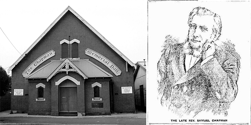
The red-brick Chapman Memorial Hall has stood in Ross Street for over one hundred and twenty years. When the foundation stone was laid on the afternoon of Saturday 24 January 1903 The Standard reported that many who had attended ‘were surprised to find that the new building was at an advanced stage of construction’.[1] It was already identified as the…

Read more

Barlow Street

by David F Radcliffe Barlow Street is one of those “internal” roadways that provide access to houses located off the main streets in Port Melbourne. Its entrance is on the eastern side of Nott Street between Liardet and Graham Streets.  Access to Barlow Street off Nott Street. Photograph by David Radcliffe. Like Florence Place, Barlow Street is a consequence of the way…

Read more

Florence Place (& Britain Street)

by David F Radcliffe When I first came across Florence Place it grabbed my attention as my mother’s name was Florence. Running between Stokes Street and Nott Street just south of Liardet Street, it affords access to the northern side of the large apartment complex that occupies most of this block. Strolling down it, I wondered why it was straight…

Read more

Church Street

Church St (highlighted), MMBW Map (detail), 1895. State Library of Victoria Church Street is the Z-shaped laneway running from Stokes Street to Nott Street highlighted above on an MMBW map from 1895. St Joseph's Roman Catholic Church, MMBW Map (detail), 1895. State Library of Victoria. The Stokes Street end of Church Street is opposite St Joseph's Roman Catholic Church which was…

Read more

Piecing Together the Past

by David F Radcliffe When researching the story of the entrepreneurial Otto Schumacher, one question proved very difficult to answer. When did the small factory he built on Esplanade East in 1890 turn into the impressive building that defined the corner of Graham Street and Esplanade East from the 1920s? With its distinctive red brick and white stucco façades and flanked…

Read more

Lind Avenue

by David Thompson Lind Avenue (highlighted), Morgan's Official Street Directory, 34th Edition, Map 36 (detail) Lind Avenue runs from Dunstan Parade to Sandridge Avenue along the western edge of Buckingham Reserve. It was probably named after Albert Eli Lind, later Sir Albert Eli Lind, who was a Minister and Deputy Premier in the Dunstan State Government as well as serving…

Read more

Stokes (and Wickham) Street

by David F Radcliffe When the first allotments of Crown Land in Sandridge (now Port Melbourne) were sold in 1850, the settlement comprised just six streets – Graham, Rouse, Stokes, Nott, Bay and Dow. While Bay Street is obvious, the origins of the names for the other five streets remains something of a mystery. Margaret Bride has written about the…

Read more

PMHPS acknowledges the generous support of the City of Port Phillip.


The content of this site (images and text) must not be reproduced in any form without the prior consent of PMHPS or the copyright holder.

Acknowledgement of Traditional Custodians

We respectfully acknowledge the Traditional Custodians of the land on which we meet and work, the Bunurong Boon Wurrung and Wurundjeri Woi Wurrung peoples of the Eastern Kulin Nation and pay respect to their Elders past, present and emerging.