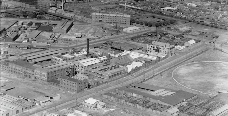
Skip to content Skip to footer
Town Hall, 333 Bay Street, Port Melbourne

Rosny Street

by David F Radcliffe Rosny Street runs between Barak Road and Howe Parade, at the eastern end of the Fishermans Bend Estate. Nearby Williamstown Road is a clue to the origin of this street’s name. Rosny Street. MMBW Map 1942: SLV During the 1920s, the double-ended, steam powered Rosny ferried commuters between Port Melbourne and Williamstown. Built at Battery Point in Hobart for the…

Read more

Streets and Reserves of the Fishermans Bend Estate

by David F Radcliffe During the preliminary phases of the Fishermans Bend Estate development, the Housing Commission of Victoria intended to name the streets numerically, i.e, First Street, Second Street, First Avenue, Second Avenue and so forth. Later their thinking changed…. Fishermans Bend was a pioneering project for the Commission which was established in March 1938 in response to the…

Read more

Strathnaver: Luxury liner and Migrant Ship

by Peter Munro Our love affair with P & O's Strathnaver began in February 1931 when she was christened with a magnum of Australia's finest burgundy.[i] Later that year, and with a population of just over one million, Melbourne shrugged off the Wall Street panic, and a world economic depression to welcome this gleaming white, three funnelled, nine deck luxury liner: the largest ship to have ever berthed at the Port of Melbourne. Her long association with these waters, bringing many “New Australians” here in the post-war period, lasted…

Read more

Edina Avenue

by David F Radcliffe Edina Avenue is a short street, with just eight houses, on the western side of R.F Julier Reserve in the Fishermans Bend Estate.  Edina Avenue. MMBW Map 1942: SLV It is named for the “Grand Old Lady of Port Phillip”, the S.S. Edina. Launched in May 1854 in Glasgow, she was something of a technological hybrid; an iron hulled, screw- powered…

Read more

Benjamin Bolton, Cash and Family Grocer

by David Thompson Interior, Benjamin Bolton, Family Grocer, Port Melbourne. c1913-c1916. Photographer Algernon Darge. State Library of Victoria. If you have visited Coles supermarket, in Bay Street, via the travellator leading from the rooftop car park, you will be familiar with this photograph. Taken by Algernon Darge around 1913-16, it shows the interior of Benjamin Bolton's Grocery store. It is held…

Read more

Cumberland Road

by David F Radcliffe Cumberland Road is one of a pair of curved streets that form the ‘entrance’ to the Fishermans Bend Estate. The other is Batman Road. Both run off “The Boulevard”, the bayside boundary of this estate conceived in the late 1930s to provide decent housing for working people. Both streets allude to the early European history of…

Read more

Mitchell Crescent

by David Thompson Mitchell Crescent is a private street that runs through the public housing estate between Nott Street and Bay Street curving towards Rouse Street at the back of the Exchange Hotel. The large block on the western side of Bay Street between Rouse Street and the beach served as the cable tram depot from 1890 until the tramway…

Read more

Johnston Street

by David F. Radcliffe Johnston Street runs from Graham Street to Beaconsfield Parade, one block back from Pickles Street. It was gazetted in 1865 along with many other streets on the eastern side of Sandridge Lagoon: Rouse Street East, Graham Street East, Liardet Street East, Esplanade East and Pickles Street. This was before any bridges crossed this dominant water feature.…

Read more

PMHPS acknowledges the generous support of the City of Port Phillip.


The content of this site (images and text) must not be reproduced in any form without the prior consent of PMHPS or the copyright holder.

Acknowledgement of Traditional Custodians

We respectfully acknowledge the Traditional Custodians of the land on which we meet and work, the Bunurong Boon Wurrung and Wurundjeri Woi Wurrung peoples of the Eastern Kulin Nation and pay respect to their Elders past, present and emerging.