
Bridge Street
by David Radcliffe
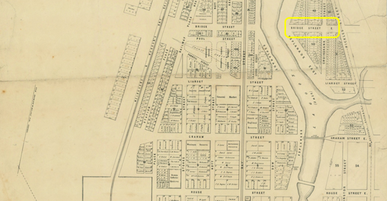
Bridge Street is one of three streets that both traverse Port Melbourne from east to west, cross the light rail tracks and extend into Fishermans Bend, the others being Ingles Street and Graham Street. Originally it only ran from the western edge of Sandridge Lagoon to the Melbourne to Hobsons Bay Railway track. As there was no bridge in the street at the time, for example across the Lagoon, it is not immediately obvious why this name was chosen. Perhaps anticipating for a future bridge over the Lagoon to neighbouring Emerald Hill?
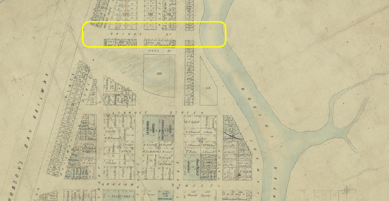
After Sandridge gained its municipal independence from Melbourne in 1860, plans were developed to subdivide and sell land on the eastern shore of the Lagoon as far as Pickles Street, the boundary with Emerald Hill (South Melbourne). This planning included the creation of an eastern extension of the major cross streets in Sandridge including Bridge Street. At this stage the only bridges over the Lagoon were at Graham Street and near Rouse Street.
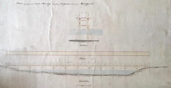
A footbridge was proposed over the Lagoon in 1863, linking the eastern and middle portions of Bridge Street. This bridge was replaced by an earth dam and road in the early 1880s when the upper portion of the Lagoon was filled in and the new Crown Land sold off in December 1883 and February 1884.[1]
By the 1870s, a westward extension of Bridge Street had been created from the railway line to the sand grounds in the heart of Fishermans Bend.
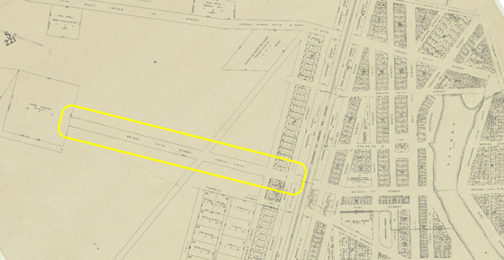
However it was not until October 1879 that tenders were called to construct a level crossing over the railway line to link the middle and western portions of Bridge Street. The work was completed in January and hailed as a “boon for those who reside on the west side of the Borough”.[2]
However there seems to have been a delay in getting the gates at the crossing open and operational. A scurrilous rumour at the time was that “there are 40 candidates for the important post of gatekeeper, and that each has been promised it”.[3]
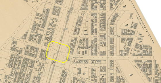
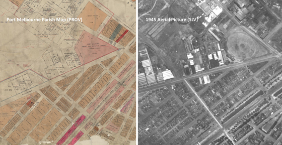
Whereas the 1878 map shows the western extension of Bridge Street as being straight and continuous either side of Williamstown Road, we know that there is an ‘off-set’ in Bridge Street as it crosses Williamstown Road. There is also a ‘dog-leg’ bend in Bridge Street as it passes Bunnings. How these came to be is not entirely clear. For one thing, historic maps do not necessarily reflect the reality on the ground. The Port Melbourne parish map, which aggregates information from the 19th and 20th centuries, suggests that Bridge Street west of Williamstown Road was not surveyed early on as only an indicative direction of the western extension of Bridge Street is shown. The aerial picture below reveals that in 1945, Bridge Street west of Williamstown Road was broad and probably unpaved. The ‘dog-leg’ is clear but the ‘offset’ less so.
It is probable that the current alignment of Bridge Street west of Williamstown Road became more defined during the post-war period as that part of Port Melbourne became more industrialised.
[1] David F Radcliffe, Changing Fortunes: Ebb and Flow in People and Place in a Pocket of Port Melbourne, Chapter 4 Lagoon Living, Penfolk Press, March 2021.
[2]1880 ‘THE ELECTION CONTEST.’, The Record and Emerald Hill and Sandridge Advertiser (Vic. : 1872 – 1881), 9 January, p. 3. , viewed 05 May 2021, http://nla.gov.au/nla.news-article108501901
[3]1880 ‘EMERALD HILL ELECTION.’, The Record and Emerald Hill and Sandridge Advertiser (Vic. : 1872 – 1881), 13 February, p. 2. , viewed 05 May 2021, http://nla.gov.au/nla.news-article108501999
2 Comments
Rodney McGregor
A fascinating story thank you David Radcliffe. I used to own and live in one of the terrace houses at the eastern end of Bridge Street (near Pickles Street), researched the terraces with Kay Rowan, and for years was unable to determine how the name Bridge Street came about. It was apparent there never was a bridge, and I then unsuccessfully looked for a link with a person of that surname. Your article confirms that a footbridge was proposed, complete with diagram, and it is marvellous to see this all presented so succinctly. Many thanks David.
David Radcliffe
Pleased you found the article interesting and informative. David.