Stokes (and Wickham) Street
by David F Radcliffe
When the first allotments of Crown Land in Sandridge (now Port Melbourne) were sold in 1850, the settlement comprised just six streets – Graham, Rouse, Stokes, Nott, Bay and Dow. While Bay Street is obvious, the origins of the names for the other five streets remains something of a mystery. Margaret Bride has written about the life of merchant James Graham, the possible person after whom Graham Street is named.
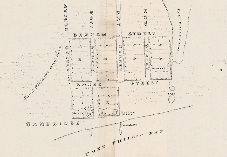
In their book, The Borough and Its People, Margaret and Graham Bride ponder if Stokes Street might have been named after John Lort Stokes. A discrepancy between the 1849 street layout and earlier plans for Sandridge provides evidence to support this theory. A street layout was developed in 1842 ahead of a proposed auction of allotments at Sandridge but due to lack of interest the land was withdrawn from sale. As Nancy U’Ren noted in 1976, the plans from 1842 had a seventh street named Wickham, to the east of Dow. However, the connection between the names Stokes and Wickham does not seem to have been made.
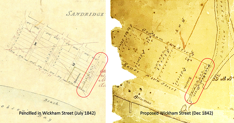
Surveyor: Robert Hoddle. Source: Public Record Office Victoria
While the street names were only pencilled in on the July 1842 plan (left) they were an integral part of the version made in December (right). Curiously, the July plan takes no account of the Sandridge Lagoon while the December one shows Wickham Street on the very edge of the Lagoon, where Esplanade West is today as it passes the Graham Hotel. Whereas Wickham Street was envisaged to run parallel to Dow, Esplanade West takes account of the actual shape of the Lagoon and changes direction, angling westward south of the hotel. The reality of the location and shape of the Lagoon meant that Wickham Street was not to be, and thus does not appear on the 1849 plan.
However, the fact that Stokes and Wickham Streets were proposed as the east and west bookends in the 1842 plan suggests the choice may have been intentional. John Clements Wickham (1798-1864) and John Lort Stokes (1812-1885) were both Royal Navy hydrographers (marine surveyors) whose careers overlapped in significant ways, not least in mapping extensive parts of the Australian coastline. Charts made by Matthew Finders and Phillip King in the early 19thcentury were corrected in the 1840s using the more complete surveys conducted by Wickham and Stokes.
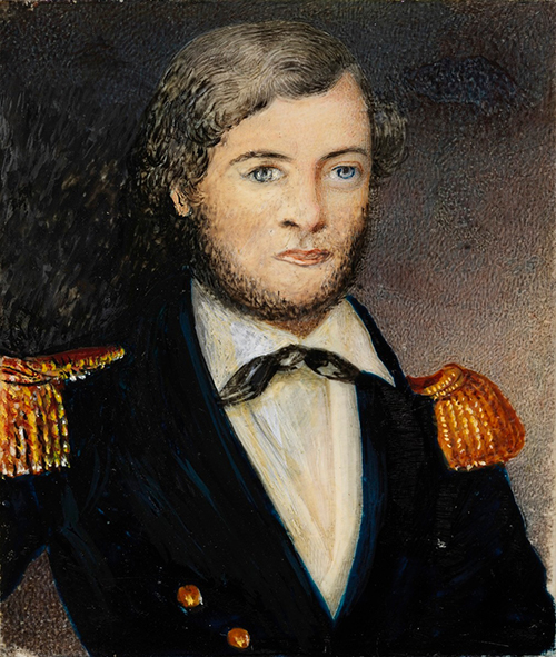
Stokes and Wickham served on all three of the surveying voyages of the HMS Beagle. Midshipman Stokes was just thirteen at the start of the 1826-1830 expedition of the Beagle to survey the coasts of Peru, Chile and Patagonia while Wickham was second lieutenant on the HMS Adventure that accompanied the Beagle. On the second Beagle voyage (1831-1836) to map other parts of the South American coast, Wickham was a lieutenant to commander FitzRoy while assistant surveyor Stokes shared a cabin with naturalist Charles Darwin on his historic journey of discovery. On the third voyage (1837-1843), this time to survey the Australian coast, Wickham was the commander until 1841 when he retired from the Royal Navy and Stokes took over command. They charted the Torres Strait, the northern and western coasts of Australia and named Port Darwin after their former travelling companion. Some of their charts were still in use during the Second World War.
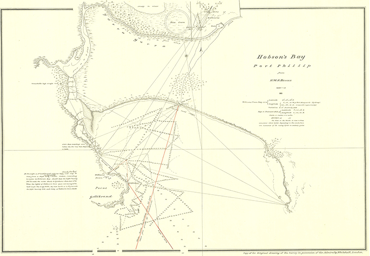
On this third voyage, HMS Beagle also charted Bass Strait and Port Phillip. They surveyed Hobsons Bay in December 1839. Stokes describes the land along the bush track from Melbourne to what is now Port Melbourne in the following terms.
We returned to the ships by a short route leading direct from Melbourne to the northern shore of Hobson’s Bay. During the walk I was much struck with the great risk that people run in selecting land from a map of this country, half of our road lying over a rich loam, and the other half over soft sand.
Potential buyers of Crown Land in Sandridge, Emerald Hill and St Kilda who assembled in a Melbourne auction room in December 1842 were also aware of such risks. While the lack of interest in the Sandridge blocks that day was largely because the reserve price was too high, some may have had concerns about a watery future for some of the proposed blocks of land along the ill-fated Wickham Street.
Wickham became the police magistrate at the Moreton Bay settlement and later the Government Resident there before Queensland became a separate colony in 1859. Wickham Terrace in Brisbane, named after him, is renowned locally as the street where leading medical specialists have their consulting rooms. Stokes was a vivacious writer and in 1846 published an extensive account of the voyage of the Beagle in Australian waters. He is also remembered for his surveys of the coastal waters around New Zealand and islands in the Pacific. Some of his charts are still in use. By the time of his retirement, Stokes had achieved the rank of Admiral.
While we are yet to find documented proof that Stokes Street was named for John Lort Stokes, the Stokes-Wickham connection points to this being the case. As for the origins of Dow, Nott and Rouse Streets, much more needs to be uncovered.
Bibliography
G. C. Bolton, Stokes, John Lort Stokes (1812–1885), Australian Dictionary of Biography, National Centre of Biography, Australian National University, https://adb.anu.edu.au/biography/stokes-john-lort-2703/text3793, published first in hardcopy 1967, accessed online 21 September 2022.
Margaret and Graham Bride, The Borough and its People: 1839-1939, Port Melbourne Historical and Preservation Society, 2013.
A. A. Morrison, Wickham, John Clements (1798–1864), Australian Dictionary of Biography, National Centre of Biography, Australian National University, https://adb.anu.edu.au/biography/wickham-john-clements-2790/text3977, published first in hardcopy 1967, accessed online 21 September 2022.
John Lort Stokes, Discoveries in Australia, Volume 1 and Volume 2, An Account of the coasts and rivers explored and surveyed during the voyage of H.M.S. Beagle in the years 1837-38-39-40-41-42-43, T & W Boone: London, 1846. https://gutenberg.net.au/ebooks/e00038.html
Nancy U’Ren, The Early Growth and Development of Sandridge, Master of Arts Thesis, University of Melbourne, 1976.