The Curious Case of King and Stone Streets with Bartlett Street Thrown in for Good Measure
by David Thompson
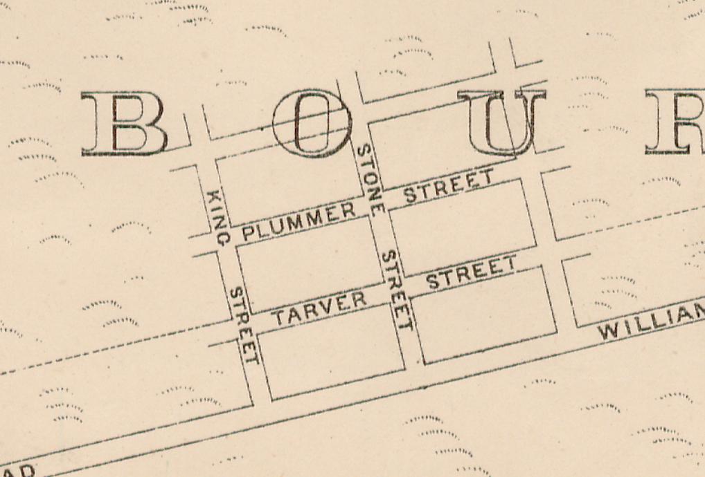
A General Plan prepared by the Melbourne Harbor Trust dated 1893[1] shows a regular grid of six streets to the west of Williamstown Road. Tarver Street, Plummer Street and a third unnamed street running parallel to Williamstown Road with King Street, Stone Street and another unnamed street running directly off Williamstown Road. Tarver and Plummer Streets, we know, are named for Port Melbourne Councillors but what of King and Stone Streets?
King Street
The origin of the name King Street is not known. Clearly in the 1890s Queen Victoria was on the throne so we can rule out a tribute to the reigning monarch and reviewing the list of Harbor Trust Commissioners does not uncover a King[2]. It doesn’t reveal a commissioner called Stone either!
Today we know King Street as Prohasky Street and Cr William Henry Prohasky was a contemporary of Crs William Richardson Tarver and James Ker Beck Plummer, one of the two men named Plummer who served on Council.
Stone Street
Today, Stone Street is called Smith Street. Charles Edward Smith, one of three Smiths that were elected to Port Melbourne Council, was also a contemporary of Tarver, JKB Plummer and Prohasky.
But what of Stone Street?
The answer appears to be very straight forward. A Melbourne and Metropolitan Board of Works (MMBW) plan from around 1894[3] shows a Stone Works facing onto Smith Street. It is not unconceivable that the road was known as Stone Street because it led to the Stone Works.
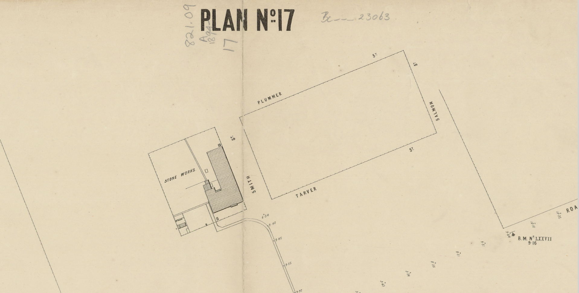
The plan does not show Prohasky (or King) Street but it does add the name Salmon to the street grid. Cr Philip Melville Salmon was also a contemporary of the councillors already mentioned in this story.
Completing the Grid
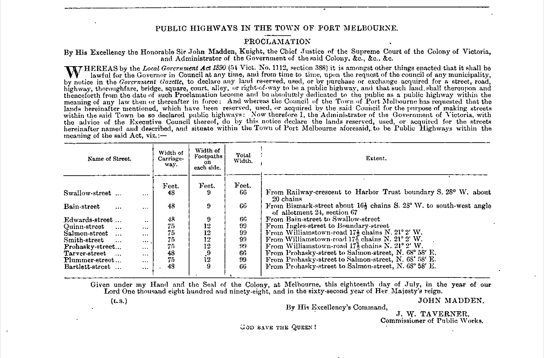
The above notice appeared in the Victorian Government Gazette of 22 Jul 1898.[4] It shows that Salmon, Smith, Prohasky, Tarver and Plummer Streets were proclaimed as Public Highways on 18 Jul 1898. The notice also gives the name of the sixth street in the grid as Bartlett which was proclaimed at the same time.
Bartlett Street
A list of Sandridge/Port Melbourne Councillors taken primarily from ‘A History of Port Melbourne’ by Nancy U’Ren and Noel Turnbull[5] and updated by PMHPS shows that the men who gave their names to these streets were all contemporaries on Port Melbourne Council with James John Bartlett completing the sextet of 1880s/1890s councillors.
James John Bartlett 1884-85 and 1890-93; Mayor 1891-92 and 1892-93.
James Ker Beck Plummer 1866-71, 1884-87, 1888-97 and 1898-1904; Mayor 1885-86 and 1889-90. [James’ father, Andrew Plummer MD was elected to the first Sandridge Council in 1860 and then also served from 1861 to 1866. He was Mayor 1862-63, 1863-64 and 1864-65.]
William Henry Prohasky 1885-93; Mayor 1888-89.
Philip Melville Salmon 1888-93; Mayor 1890-91.
Charles Edward Smith 1889-1892.
William Richardson Tarver 1884-1899; Mayor 1886-87.
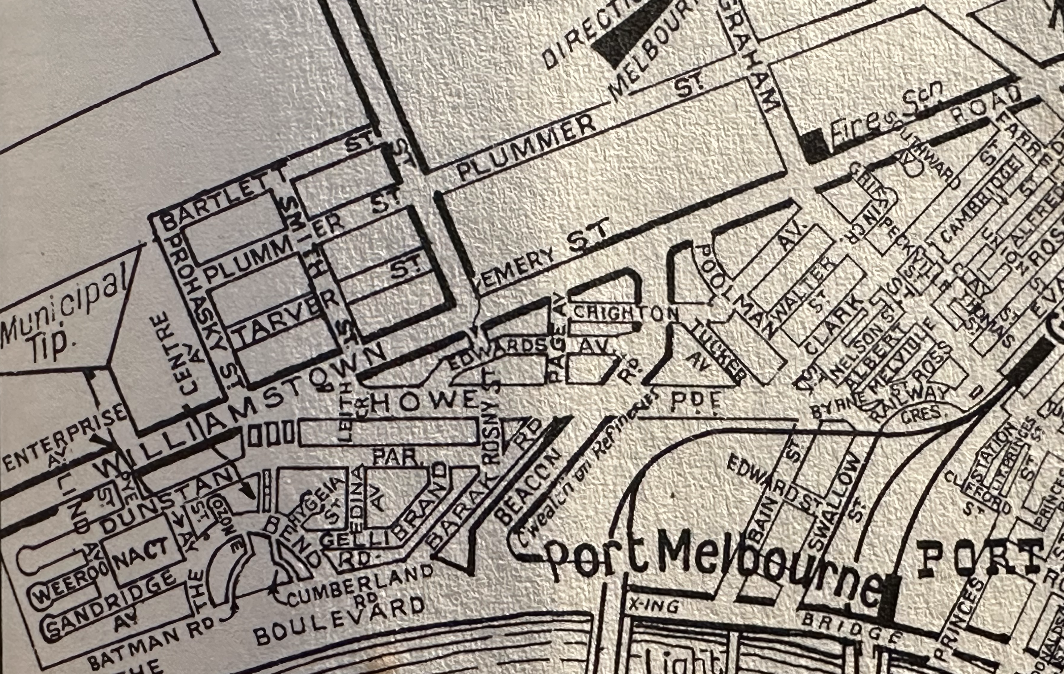
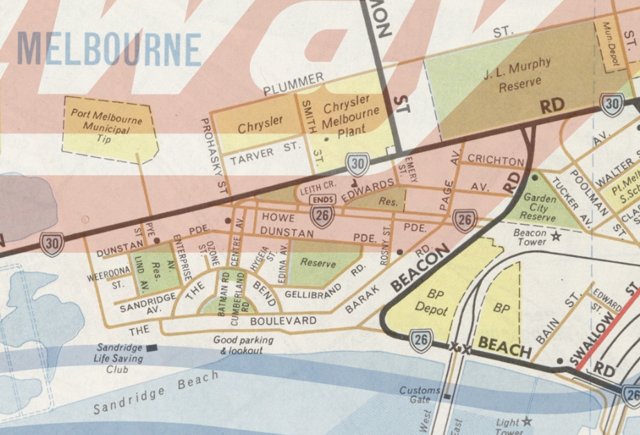
Industrial development within this area has affected the grid. The Third Edition of Robinson’s Street Directory of Melbourne and Suburbs (c 1950s)[6] above, shows the grid of six streets intact with Plummer Street extending above Salmon Street to Bridge Street but by the first edition of the Melway Street Directory of Greater Melbourne (1966)[7] below, Bartlett Street is no longer included and the Chrysler Melbourne Plant has caused Tarver Street to be truncated at Smith Street.
Now in the 2020s, this area has been rezoned from industrial to, primarily, residential in the Wirraway precinct within the Fishermans Bend Urban Renewal Area. Our 1890s grid of streets is set for much more change in the coming decades.
[1] 1893 Melbourne Harbor Trust general plan shewing river and harbor improvements, State Library of Victoria, viewed 26 Jun 2023, http://handle.slv.vic.gov.au/10381/114248
[2] Hoare, B. Melbourne Harbor Trust Commissioners Jubilee Report, 1877 – 1927, p. 267-269.
[3] c1894 Melbourne and Metropolitan Board of Works plan, No. 17 Port Melbourne, State Library of Victoria, viewed 26 Jun 2023, http://handle.slv.vic.gov.au/10381/143067
[4] 1898 ‘PUBLIC HIGHWAYS IN THE TOWN OF PORT MELBOURNE’, Victorian Government Gazette, No. 71, 22 July, p. 2849
[5] 1983 U’Ren, Nancy & Turnbull, Noel, A History of Port Melbourne, Oxford University Press, Melbourne, p. 273-275
[6] c1950s Robinson’s Street Directory of Melbourne and Suburbs, Ed. 3, Map 47.
[7] 1966 Melway Street Directory of Greater Melbourne, Ed. 1, Map 56, viewed 26 Jun 2023, https://digitised-collections.unimelb.edu.au/items/18db5ce6-bf50-45c0-be02-c45fa560e783