Survey Markers around Port
by David F Radcliffe
Have you ever wondered what all those nails with coloured markings around them are on footpaths? Or have you come across an odd metal disc lurking in the grass or an unusual cover plate amongst the shrubs on the nature strip? If they look like any of the following, then they are part of the system surveyors use to define location and place. While we now have access to Global Positioning Satellites (GPS) on our phones, the use of physical markers on the ground goes back to the beginning of European settlement. The technology has changed dramatically, but the essentials of surveying remain the same as those William Darke used when he surveyed this place he called Sandridge in 1836, camped out on the foreshore in his well-appointed caravan.
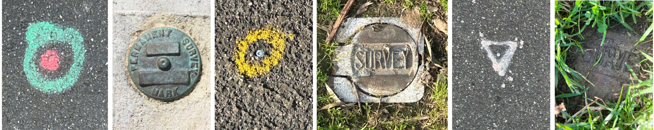
The nails are temporary markers used in a local survey, for instance, related to checking the boundaries of a property. The more substantial metal objects are permanent markers (PM). These PMs are in defined locations and used as reference points for local survey work. There are thousands of permanent markers around the country maintained by the relevant government agency. The precise coordinates of each location are related to the Geocentric Datum of Australia (GDA).[1] The elevation of each marker is measured relative to the Australian Height Datum (AHD), based on the mean sea level around Australia measured in the late 1960s.[2]
Here are a few examples of permanent markers around the Borough. Melbourne South PM 536 is located alongside the rubbish bin on the beach side of Beaconsfield Parade at the intersection with Pickles Street. It is near the location of the “marked post on the seacoast of Hobson’s Bay” that was used to delineate the boundary between the municipalities of Sandridge and Emerald Hill (South Melbourne) in 1860. Shown below is the permanent marker sketch plan (right) with a locational photo.
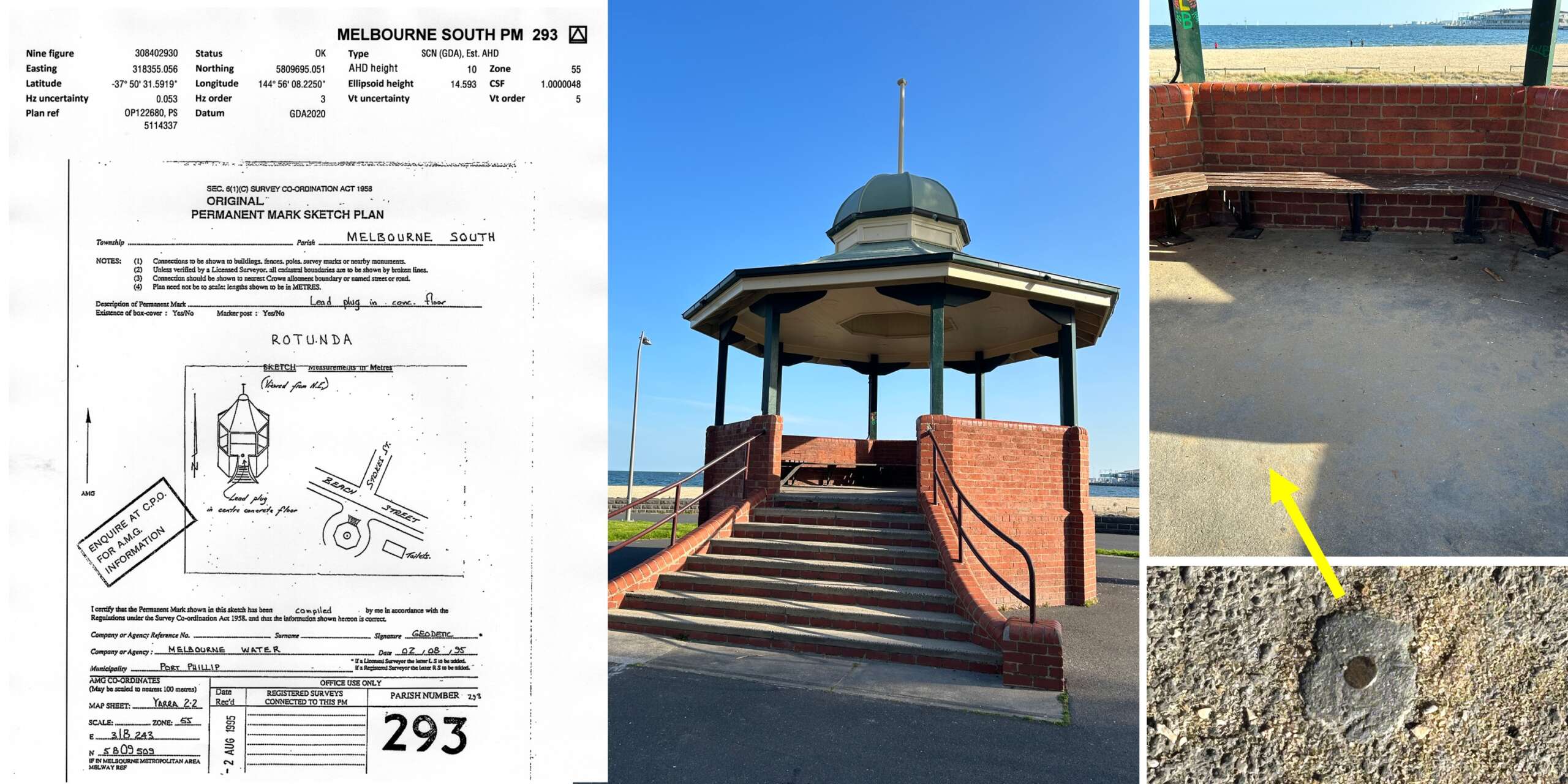
Not every permanent marker is this large and obvious. For example, Melbourne South PM 293 is a small lead plug located at the centre of the Rotunda on Beach Street. It takes a keen eye on a sunny day to find it even when you know what you are looking for.
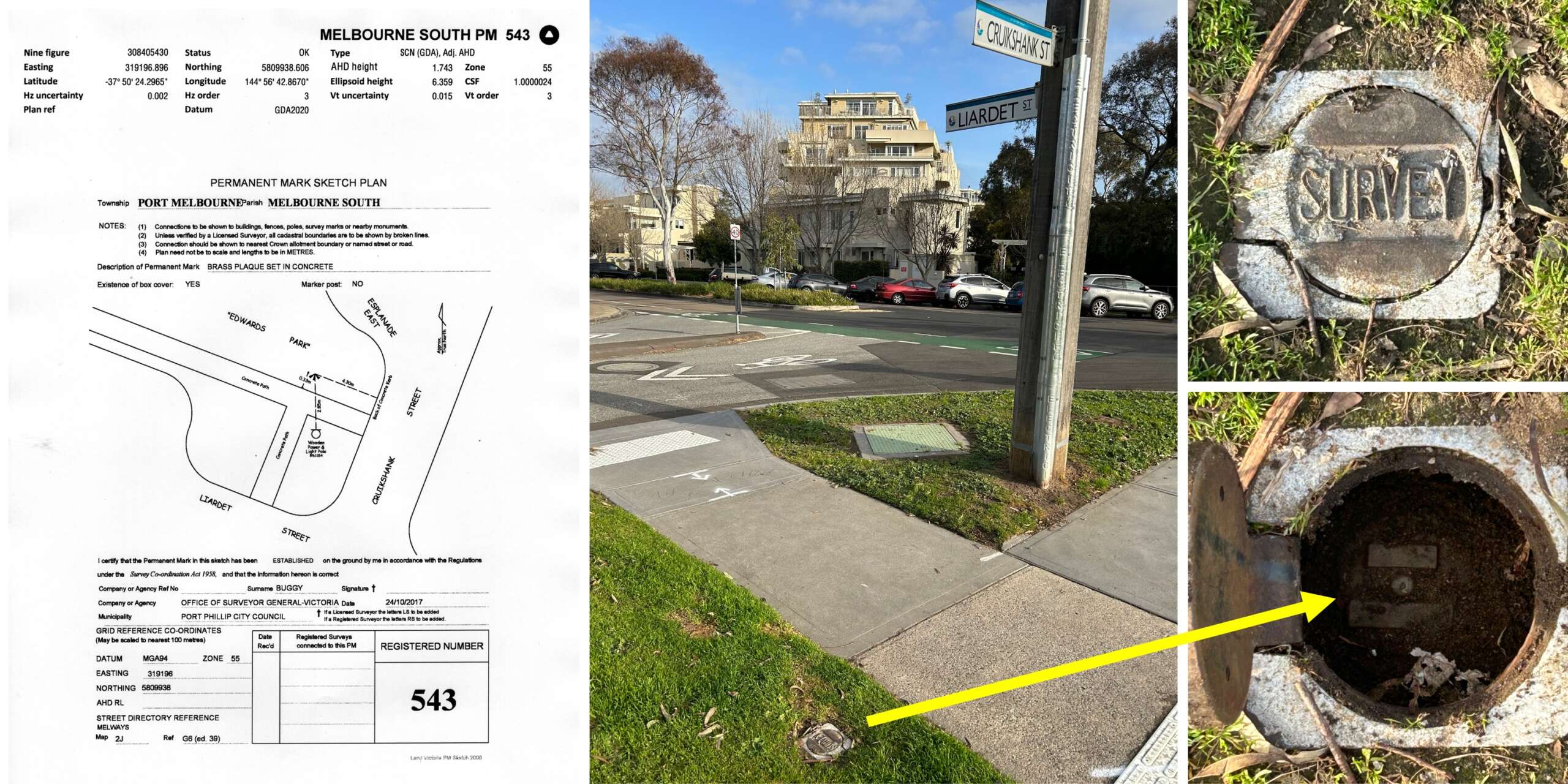
Some permanent markers are located under a cover plate. Below is Melbourne South PM 543 near the intersection of Liardet and Cruikshank Streets, at the southwest corner of Edwards Park.
Some markers are in the form of a prominent structure used to get a local directional bearing, e.g. the top of the flagpole on the Town Hall. The documentation for these so-called coordinated marks often includes an endearing sketch of the structure, although it can take some imagination to recognise.
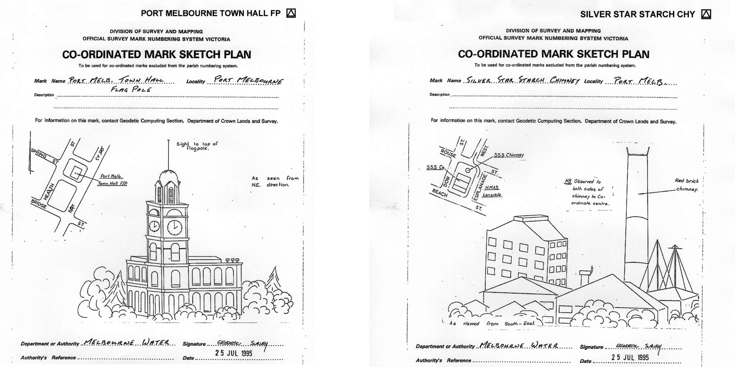
Artistic licence was used to depict the Town Hall and much has changed around what is described as the red brick chimney of the Silver Star Starch factory. Why the Lead Light diagram is a map of Port Melbourne rather than a depiction of the elegant structure itself is hard to fathom.
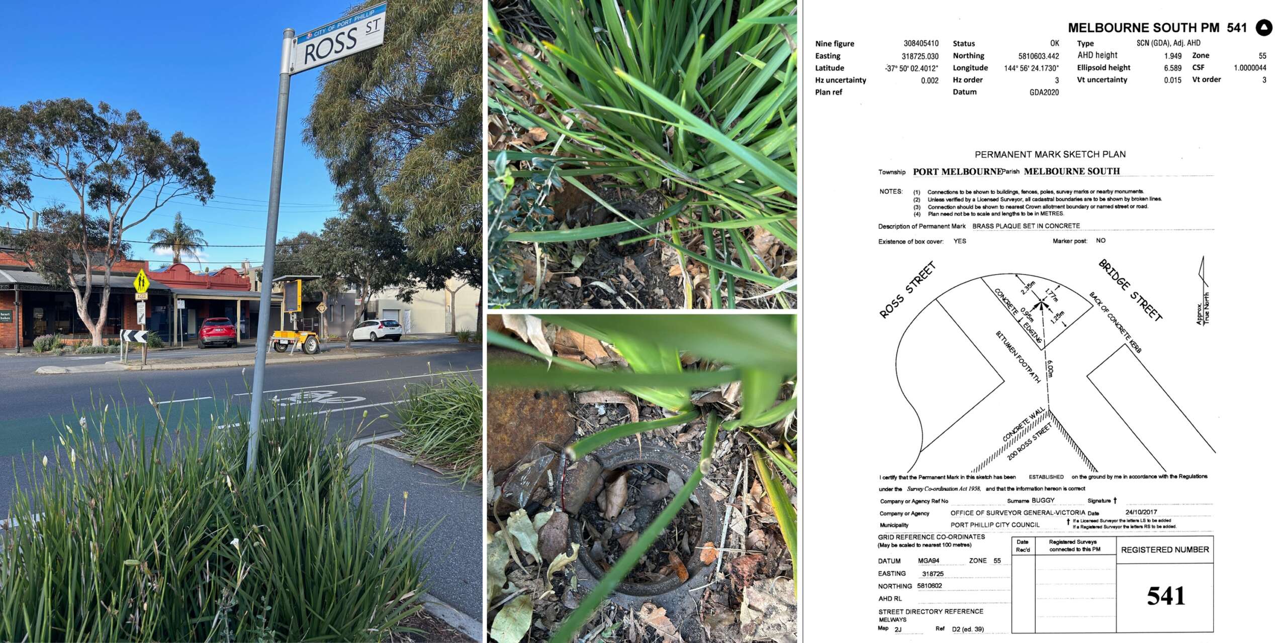
Locating some of the permanent markers around Port Melbourne can be very difficult. Often, they are hidden or half-buried in landscaping, as is the case of Melbourne South PM 541 at the intersection of Ross and Bridge Streets.
Permanent markers are meant to be just that, permanent. However, in some cases, there is no sign of the permanent marker at the location described.
But then again, permanence is a relative concept when you realise the Australian Plate is moving in a north-to-north easterly direction at about 7cm a year. While our permanent markers are all travelling in unison, our GPS position needs to be periodically updated so the rest of the world knows where we are.
[1] https://www.ga.gov.au/scientific-topics/positioning-navigation/geodesy/datums-projections/gda2020 Accessed 16 September 2023.
[2] https://www.ga.gov.au/scientific-topics/positioning-navigation/geodesy/ahdgm/ahd Accessed 16 September, 2023.