Skip to content Skip to footer
Town Hall, 333 Bay Street, Port Melbourne

Bridge Street

by David Radcliffe 
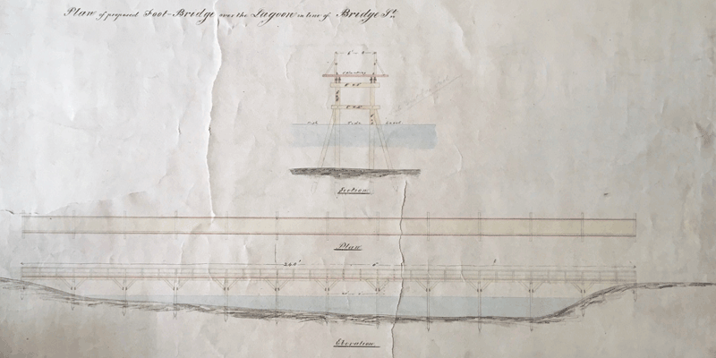
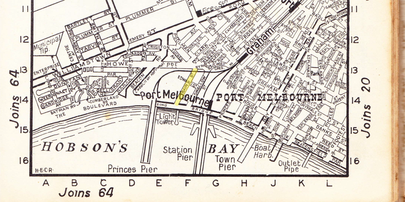
Bridge Street is one of three streets that both traverse Port Melbourne from east to west, cross the light rail tracks and extend into Fishermans Bend, the others being Ingles Street and Graham Street. Originally it only ran from the western edge of Sandridge Lagoon to the Melbourne to Hobsons Bay Railway track. As there was no…

Read more

A Corner Shop

In the days before supermarkets and large shopping centres the people of Port Melbourne and other inner suburbs shopped every day at small local shops located cheek by jowl amongst their own houses. One such shop was located on the corner of Esplanade East and Spring Street East. PMHPS has a digital copy of a photograph album compiled…

Read more

Norma Barnett Lane

Norma Barnett came to Port Melbourne in 1953 to work at the Melbourne City Mission. The Mission had been established a century earlier to give aid to the thousands of immigrants who had flocked to Victoria in the gold rush, failed to make their fortune and were stranded, destitute. Just behind the Fountain Inn (now The Cornerstone) stood the…

Read more

James Graham: was Graham Street, Port Melbourne named after this man?

by Margaret Bride Detail, Plan of allotments marked at Sandridge in the parish of South Melbourne / surveyed by Lindsay Clarke Assit. Surr., 1849. State Library of Victoria. In 1849 the government surveyor published a Street Plan of Sandridge showing a simple grid of streets with six blocks bounded by the newly named streets of Rouse, Graham, Stokes, Nott and Dow, names that have remained…

Read more

Ellinis Mews

Pedestrian access to Ellinis Mews from Beacon Road, Photograph by David Thompson Ellinis Mews is a short residential street in Beacon Cove but I'm not sure where the connection with stables is other than in the developers' minds. To me it is a Court or what we would have called in Ireland a Close or, if we wanted to be…

Read more

The Graham

Pubs have more lives than cats. The Graham Hotel is about to embark on a new one. The Graham Family Hotel was constructed on the shallow shore of the Sandridge Lagoon beside the Graham Street footbridge in 1872 for Alfred J. Johnson, a stevedore. The substantial, two storey brick structure in the Free Classical style was designed by architect Frederick…

Read more

Legon Street

by David Radcliffe Legon Street is one of those tiny streets in Port Melbourne tucked away off the main thoroughfares, not easy to find and doubtless a bane in the life of delivery drivers and removalists. It is a dead end street with relatively narrow entrances off Dow and Graham Streets. When the land bounded by Graham, Dow and Rouse…

Read more

Aircraft of Fishermans Bend

At the bottom end of Lorimer Street in the shadows of the Westgate Bridge there is a series of streets that reflect one the key industries that has occupied the area since the mid 1930s. Although now part of the City of Melbourne, these streets are named after aircraft associated with the Commonwealth Aircraft Corporation and Government Aircraft Factories on Fishermans Bend and are…

Read more

Bain Street

There is no need to go looking on any 21st Century map for Bain Street, Port Melbourne, you won't find it. Bain Street was gazetted on 27 July 1898 and as you can see from the map from around the 1950s (below), it was west of Swallow Street and it wasn't quite 100 years old when it succumbed…

Read more

PMHPS acknowledges the generous support of the City of Port Phillip.


The content of this site (images and text) must not be reproduced in any form without the prior consent of PMHPS or the copyright holder.

Acknowledgement of Traditional Custodians

We respectfully acknowledge the Traditional Custodians of the land on which we meet and work, the Bunurong Boon Wurrung and Wurundjeri Woi Wurrung peoples of the Eastern Kulin Nation and pay respect to their Elders past, present and emerging.